Coe Park Preservation Fund
Henry W. Coe State Park
The Wilderness Next Door
Fire Weather Research
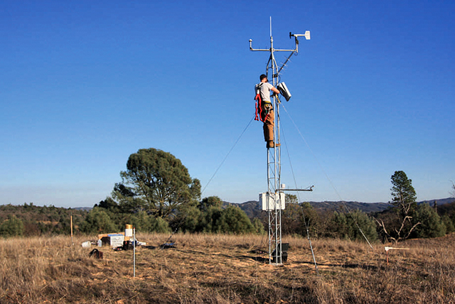
The RAWS Station Being Assembled on Cordoza Ridge
On December 22, the Remote Automated Weather Station (RAWS) located on Cordoza Ridge in Coe Park became one of nearly 2,200 interagency weather stations across the country that continuously place weather data online.
Coe Park volunteers began exploring the feasibility of constructing a RAWS station in Coe in 2003 looking at possible locations, funding sources, and sources for equipment. In January 2009 Dave Stocks, a Coe volunteer from 1985 and retired fire captain from the Santa Clara County Fire Department, assembled an inter-agency group to look at the need for additional weather data across Santa Clara County. The first meeting consisted of staff from the Santa Clara County Parks Department, Midpeninsula Regional Open Space District, State Parks, and San Jose State University (SJSU) Meteorology and Climate Science Department. In April 2009 members from the Santa Clara Valley Water District, San Jose Fire Department, Cal Fire, and the California Emergency Management Agency were added to the group.
In May 2009, researchers boarded a Cal Fire helicopter and flew over Coe Park looking at possible sites for the first weather station. There was no good location in the immediate visitor center area where the sloping terrain, buildings, and trees would all influence the wind and rainfall readings. But conditions on Cordoza Ridge across Soda Springs Canyon from the visitor center area at an elevation of 2,331 feet would closely resemble those at the visitor center.
In February 2011, State Park Sector Superintendent Eddie Guaracha, Cal Fire Battalion Chief Dave McLean, Dr. Craig Clements of SJSU's Meteorology and Climate Science Department, and Chris Weske met in Morgan Hill to come to final agreement about a station to be installed on Cordoza Ridge. The $12,000 needed would come from SJSU and Cal Fire. The station was announced at the April Bay Area Fire Weather Cooperators Meeting.
If you look carefully to the southeast from the visitor center area at an open, grassy meadow on top of Cordoza Ridge you can see the station; it's an open lattice, twenty foot tower. The tower base is staked in place and the tower is secured by three guy lines. No excavation was needed for the installation. The station is powered by a solar panel and records temperature, dew point, relative humidity, wind speed, wind direction, solar radiation, rainfall, fuel temperature, and ten-hour fuel moisture. The instruments (with the exception of rainfall and fuel moisture) are mounted on the tower; the rain gauge and fuel moisture gauge are installed on the ground adjacent to the tower. Prior to being installed on Cordoza Ridge, all instruments were tested in the lab at SJSU.
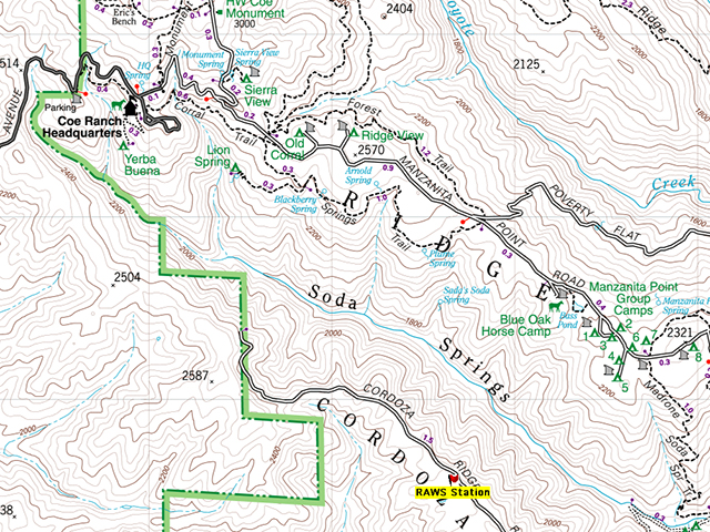
The RAWS Station Location on Cordoza Ridge
Dr. Clements has been a critical player in the venture to install a RAWS at Coe Park. He is active in supporting local prescribed burns with weather instruments and sits on the National Interagency Fire Center subcommittee for Fire Weather Standards. Craig handled purchasing the station components, coordinating with the state and national agencies involved, and installing the equipment. SJSU will take responsibility for the maintenance and calibration of the station per standards specified by the National Wildfire Coordinating Group.
Data is transmitted hourly to a Geostationary Operational Environmental Satellite (GOES) which is operated by the National Oceanic and Atmospheric Administration. The data is then distributed to the Bureau of Land Management, Weather Information Management System, the Western Regional Climate Center and others. You can access data from the weather station at the
MESOWEST Station Interface. At this time, we are exploring a radio link between the station and the visitor center that would enable the display of conditions to be updated every ten minutes.
Although the station was installed to meet the needs of wildland fire interests, anyone can go above link and check out the current weather conditions. Planning a trip to the park? Check out the weather station to see if you should pack a warm jacket, or perhaps a couple of extra water bottles.